简介:
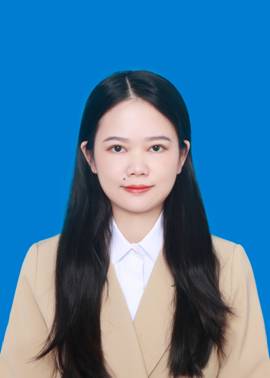
文大为,讲师,2018年毕业于武汉大学摄影测量与遥感专业,被授予工学博士学位。主要从事遥感影像处理,变化检测等方面的研究。在Remote Sensing of Environment, IEEE Transactions onGeoscience and Remote Sensing, IEEE Geoscience and Remote Sensing Magazine等SCI刊物发表论文10余篇,主持国家自然科学基金(青年项目)和中国博士后科学基金面上项目。
学术论文:
[1]Dawei Wen, Xin Huang, Francesca Bovolo, Jiayi Li, Xinli Ke, AnluZhang, and Jón Atli Benediktsson, “Change detection fromvery-high-spatial-resolution optical remote sensing images: methods,applications, and future directions”,IEEE Geoscience and Remote SensingMagazine, 10.1109/MGRS.2021.3063465, 2021. (SCI中科院一区,TOP期刊)
[2]Xin Huang*,Dawei Wen*, Jiayi Li, and Rongjun Qin, “Multi-levelmonitoring of subtle urban dynamics for megacities of China usinghigh-resolution multi-view satellite imagery”,Remote Sensing ofEnvironment, vol. 196, pp. 56-75, 2017 (SCI中科院一区,TOP期刊)
[3]Xin Huang, Jiongyi Huang,Dawei Wen*, and Jiayi Li*, “An updatedMODIS global urban extent product (MGUP) from 2001 to 2018 based on anautomated mapping approach”,International Journal of Applied EarthObservation and Geoinformation, vol. 95, pp. 102255, March 2021. (SCI中科院一区,TOP期刊)
[4]Dawei Wen, Xin Huang, Liangpei Zhang, and Jon Alti Benediktsson,“A novel automatic change detection method for urban high-resolution remotelysensed imagery based on multiindex scene representation”,IEEETransactions on Geoscience and Remote Sensing, vol. 54, no. 1, 2016.(SCI中科院二区,TOP期刊)
[5]Dawei Wen, Xin Huang, Anlu Zhang, and Xinli Ke, “Monitoring 3Dbuilding change and urban redevelopment patterns in inner city areas of Chinesemegacities using multi-view satellite imagery”,Remote Sensing,vol. 11, no. 7, pp. 763, 2019. (SCI中科院二区)
[6]Dawei Wen, Xin Huang, Hui Liu, Wenzhi Liao, and Liangpei Zhang,“Semantic classification of urban trees using very high resolution satelliteimagery”,IEEE Journal of Selected Topics in Applied Earth Observationand Remote Sensing, vol. 4, no. 4, 2017. (SCI中科院二区)
[7]Xin Huang,Dawei Wen, Junfeng Xie, and Liangpei Zhang, “Qualityassessment of panchromatic and multispectral image fusion for the ZY-3satellite: from an information extraction perspective”,IEEE Geoscienceand Remote Sensing Letters, vol. 11, no. 4, 2014. (SCI中科院二区)
[8]Tao Zhang, Xin Huang*,Dawei Wen*, and Jiayi Li, “Urban densityestimation from high-resolution imagery using multiple features and supportvector regression”,IEEE Journal of Selected Topics in Applied EarthObservations and Remote Sensing, vol. PP, no. 99, 2017. (SCI中科院二区)
[9]Hui Liu, Xin Huang*,Dawei Wen*, and Jiayi Li, “The use oflandscape metrics and transfer learning to explore urban villages in China”,RemoteSensing, vol. 9, no. 4, 2017. (SCI中科院二区)
[10]Dawei Wen, Song Ma, Anlu Zhang, and Xinli Ke, “Spatial patternanalysis of the ecosystem services in the Guangdong-Hongkong-Macao Greater BayArea using Sentinel-1 and Sentinel-2 Imagery based on deep learning method”,Sustainability,vol. 13, pp.7044, 2021. (SCI/SSCI中科院三区)
[11]QingyuLi, Xin Huang*,Dawei Wen*, and Hui Liu, “Integrating multipletextural features for remote sensing image change detection”,PhotogrammetricEngineering & Remote Sensing, vol. 83, no.2, 2017. (SCI中科院四区)
[12]Yang Lu, Jiansi Yang, Min Peng, Tian Li,Dawei Wen, and XinHuang,“Monitoring ecosystem services in the Guangdong-Hong Kong-Macao GreaterBay Area based on multi-temporal deep learning”, Science of TheTotal Environment, vol. 822, no. 153662, 2022. (SCI中科院二区)
[13]Chun Liu, Xin Huang,Dawei Wen, Huijun Chen, and Jianya Gong,“Assessing the quality of building height extraction from Ziyuan-3 multi-viewimagery”,Remote Sensing Letters, 2017. (SCI中科院四区)
[14]Xin Huang, Junjing Yang, Jiayi Li, andDawei Wen, “Urbanfunctional zone mapping by integrating high spatial resolution nighttime lightand daytime multi-view imagery”,ISPRS Journal of Photogrammetry andRemote Sensing, vol. 175, pp. 403-415, 2021. (SCI中科院一区,TOP期刊)
[15]Long li, Xin Huang, Jiayi Li, andDawei Wen, “Quantifying thespatiotemporal trends of canopy layer heat island (CLHI) and its drivingfactors over Wuhan, China with satellite remote sensing”,Remote sensing,vol. 9, no. 6, 2017. (SCI中科院二区)
[16]Dawei Wen, Hui Liu, Jiayi Li, and Xin Huang, “Multi-level changedetection in urban areas using ZY-3 multi-temporal stereo imagery”,JointUrban Remote Sensing Event (JURSE) 2017. (EI)
[17]文大为,黄昕. “基于多视角卫星影像的三维建筑物变化和城市再开发模式研究”,2019年中国地理学大会.(会议论文)
[18]文大为,刘纯,黄昕,龚健雅,“基于资源三号多视角影像的多级变化检测方法研究”,第20届中国遥感大会,2016. (第20届中国遥感大会“优秀论文奖”)
主持项目:
[1]国家自然科学基金青年项目,时空谱角全属性高分辨率遥感影像的跨维度联合特征提取与三维变化监测研究
[2]中国博士后科学基金面上项目,面向高分辨率多角度遥感影像的土地变化检测方法
[3]横向课题,高分辨率光学影像样本数据标记服务
联系方式:
daweiwen_whu@163.com